-
About District
Introduction of District
ইতিহাস ও ঐতিহ্য
ভৌগলিক ও অর্থনৈতিক
অন্যান্য
-
District Administration
Officers & Staffs
About Sections
Important Information
Innovation Activities
-
Govt. Offices
Security & Discipline Affairs
Education & Culture
-
District Primary Education office
-
District Education office
-
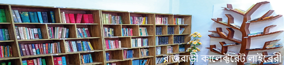
রাজবাড়ী জেলা সরকারি গণগ্রন্থাগার
-
জেলা উপানুষ্ঠানিক শিক্ষা ব্যুরো
-
Shilpa Kola academy
-
Shishu Academy
-
District sports office
-
District Information Office
-
Primary Teacher\'s Training Center
-
Rajbari Technical Training center
-
Integrated Visually Impaired Educational Institution, Rajbari
Agriculture & Food
-
Agriculture Extension Dept.
-
Dist. Food Controller Office
-
District Fisheries Office
-
District Livestocs Office
-
District Seed Certification Agency Office
-
Inspector(Jute) Department of Jute, Rajbari
-
Dept. of Agricultural Marketing
-
বাংলাদেশ নিরাপদ খাদ্য কর্তৃপক্ষ, জেলা কার্যালয়, রাজবাড়ী
-
Senior Assistant Director, Seed Marketing, BADC, Rajbari
Engineering
Communication & Engineering
Human Resources
-
Dept. of Social Service
-
Dept. of Youth Development
-
Dept. of Women Affairs
-
BRDB
-
District Employment & Manpower Office, Rajbari
-
Cooperation Office
-
Protibondhi Sheba O Sahajjo Kendro, Rajbari
-
Islamic Foundation
-
Integrated Visually Impaired Educational Institution, Rajbari
-
Jatyo Mohila Sangstha, District Office, Rajbari
-
Urban community Development office, Rajbari
-
Prabation office, Rajbari
-
Youth Training Center
Other Offices
-
Office of the Tax Commissioner
-
Office of the District Register
-
Customs & Duty
-
District Savings Office
-
District Accounts Office
-
District Election office
-
শিল্প সহায়ক কেন্দ্র, বিসিক
-
Passport office
-
Local Statistics Office
-
Forest Dept.
-
District Relief & Rehabilitation Office
-
Department of Environment, Rajbari District Office, Rajbari
-
District Primary Education office
-
Local Govt
District Council
Upazila Council
Union Council
-
Other Institutions
Educational Institutions
Organizations
বেসরকারি প্রতিষ্ঠান
-
E-Service
জাতীয় ই-সেবা
জেলা ই-সেবা কেন্দ্র
-
Gallery
--------
- APA ageements
-
Hi-Tech Park Information
Park Information
- Online License Management
- Online Hearing
- Necessary Application Forms
-
About District
Introduction of District
ইতিহাস ও ঐতিহ্য
ভৌগলিক ও অর্থনৈতিক
অন্যান্য
-
District Administration
Officers & Staffs
About Sections
Important Information
Innovation Activities
-
Govt. Offices
Security & Discipline Affairs
Education & Culture
- District Primary Education office
- District Education office
- রাজবাড়ী জেলা সরকারি গণগ্রন্থাগার
- জেলা উপানুষ্ঠানিক শিক্ষা ব্যুরো
- Shilpa Kola academy
- Shishu Academy
- District sports office
- District Information Office
- Primary Teacher\'s Training Center
- Rajbari Technical Training center
- Integrated Visually Impaired Educational Institution, Rajbari
Agriculture & Food
- Agriculture Extension Dept.
- Dist. Food Controller Office
- District Fisheries Office
- District Livestocs Office
- District Seed Certification Agency Office
- Inspector(Jute) Department of Jute, Rajbari
- Dept. of Agricultural Marketing
- বাংলাদেশ নিরাপদ খাদ্য কর্তৃপক্ষ, জেলা কার্যালয়, রাজবাড়ী
- Senior Assistant Director, Seed Marketing, BADC, Rajbari
Engineering
Communication & Engineering
Human Resources
- Dept. of Social Service
- Dept. of Youth Development
- Dept. of Women Affairs
- BRDB
- District Employment & Manpower Office, Rajbari
- Cooperation Office
- Protibondhi Sheba O Sahajjo Kendro, Rajbari
- Islamic Foundation
- Integrated Visually Impaired Educational Institution, Rajbari
- Jatyo Mohila Sangstha, District Office, Rajbari
- Urban community Development office, Rajbari
- Prabation office, Rajbari
- Youth Training Center
Other Offices
- Office of the Tax Commissioner
- Office of the District Register
- Customs & Duty
- District Savings Office
- District Accounts Office
- District Election office
- শিল্প সহায়ক কেন্দ্র, বিসিক
- Passport office
- Local Statistics Office
- Forest Dept.
- District Relief & Rehabilitation Office
- Department of Environment, Rajbari District Office, Rajbari
-
Local Govt
District Council
Upazila Council
Union Council
-
Other Institutions
Educational Institutions
Organizations
বেসরকারি প্রতিষ্ঠান
-
E-Service
জাতীয় ই-সেবা
জেলা ই-সেবা কেন্দ্র
-
Gallery
--------
-
APA ageements
জেলা প্রশাসক, রাজবাড়ী এবং বিভাগীয় কমিশনার, ঢাকা এর মধ্যে স্বাক্ষরিত বার্ষিক কর্মসম্পাদন চুক্তি
অতিরিক্ত জেলা প্রশাসক (রাজস্ব), রাজবাড়ী এবং চেয়ারম্যান, ভূমি সংস্কার বোর্ড এর মধ্যে স্বাক্ষরিত বার্ষিক কর্মসম্পাদন চুক্তি।
-
Hi-Tech Park Information
Park Information
-
Online License Management
Online License
-
Online Hearing
মামলার তালিকা
এডমিন লগইন
-
Necessary Application Forms
Job Application Form
ইট প্রস্তুতকরণ লাইসেন্সের আবেদন
হোটেল/রেঁস্তোরার লাইসেন্সের আবেদন
বালুমহাল ইজারা দরপত্রে অংশগ্রহণের জন্য তালিকাভুক্তির আবেদন
ভিপি সম্পত্তি লিজ নবায়নের আবেদন
Rajbari district is under the Dhaka division. Its area is 1204 Sq.km. Rajbari district is located in between 23°35’ to 23°55’ North Latitudes and in between 89°09’ to 89°55’ East Longitudes.The district of Pabna to the North , Faridpur and Magura districts to the South , Manikganj district to the East and Kushtia and Jhenaidah districts to the West. Almost all the region of the district is made by sediment of mighty river Padma .The main rivers of this district are Padma,Gorai,Horai and Chandna etc . Annual average temperature is maximum 35.8° centigrade and minimum 12.6° centigrade. Annual rainfall is 2105 mm. Humidity is 75%. The flood of 1961,1971,1987 and 1988 severely damaged Rajbari.During the flood of 1987 and 1988 about 97% houses of the city went 3 feet under water.


Planning and Implementation: Cabinet Division, A2I, BCC, DoICT and BASIS
Technical Assistance:
![]()
Developed By: